Pollution Mapping
by Beth Falls, Ph.D.
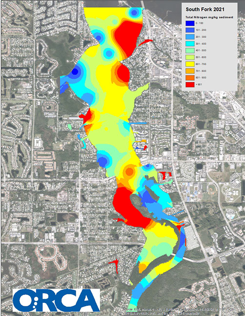
ORCA’s pollution mapping projects are the cornerstone to our ecotoxicity science program. By mapping scientific data in a visually intuitive way (example above), we are making pollution visible. The goal is to identify areas within the Indian River Lagoon (IRL) and its contributing water bodies where anthropogenic (i.e. originating in human activity) pollutants are accumulating. These maps serve as a blueprint for ORCA and others to focus their efforts to stop pollution at its source.
To date, ORCA scientists have created pollution maps of approximately 70 linear miles within our local waterways (you can access all of our maps on our website). Our first pollution map was completed between the two bridges in Central Vero Beach in 2011. Sometimes these maps alone can result in conservation action. For example, we presented our Central Vero Maps at a Vero Beach City Council meeting and based on our presentation the council members voted to enact a fertilizer blackout period in Vero Beach. In other cases, additional monitoring is needed. Knowing where pollution is accumulating, we can then track it back to its source. We do this by going upstream from the “hot spots” identified by our pollution maps. We are very proud of our Pollution Mapping projects – they have evolved from measuring just three parameters (relative toxicity, total nitrogen, and total phosphorus in sediment) for our first project in Central Vero, to nineteen parameters in our most recent pollution mapping project in the South Fork of the St. Lucie River completed in the summer of 2021.
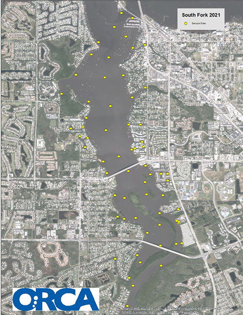
To complement our Pollution Mapping projects, which include dense sampling (e.g. the image below shows our sampling sites within the South Fork) at one point in time, our
Pollution Mapping Citizen Science project involves ongoing quarterly monitoring of specific sites. The Citizen Science Pollution Map
ping sites are selected based on the results of our larger Pollution Mapping projects.The methods that ORCA’s Pollution Mapping Citizen Scientists perform in the field and laboratory are exactly the same methods that ORCA’s scientists developed and perform as part of our larger Pollution Mapping projects. This is unique among citizen science projects. ORCA did not create a project to fit citizen scientists, but rather trains citizen scientists to do ORCA science which includes appropriate quality controls and validations to ensure accurate data. The complexity of the issues within the IRL – as well as the variety of sources throughout the IRL – can only be understood through the accumulation of large amounts of data that is robust both spatially and longitudinally. Now that we are over two full years (with nine quarterly sampling events completed) into our Pollution Mapping Citizen Science project, we are beginning to see the types of trends that will lead to meaningful conservation action. The accumulation of this volume of data simply would not be possible without the hard work and commitment of our Pollution Mapping Citizen Science teams.
 While the term “citizen science” was not coined until the mid-1990s, the concept of utilizing members of a community to assist in scientific research has been conceptually around for more than 2,000 years. In fact, in ancient China, citizens concerned with migratory locust outbreaks devastating their harvests starting tracking these occurrences and have since assisted scientists in better predicting their appearances. Citizen science is the idea that members of a community directly contribute to scientific research and data collection with participation in projects ranging from simplistic qualitative observations to more complex meta-analyses.
Citizen science should be a mutualistic relationship in that volunteers are helping researchers maximize the amount of data collected on a project but in return, citizen scientists are increasing their scientific understanding of complex environmental issues, improving their skillset, and immersing themselves in actionable projects that will improve the health of the Indian River Lagoon and its inhabitants.
ORCA welcomes people from all backgrounds and experiences the opportunity to get involved in our citizen science research. For more information, please register for one of our Introduction to ORCA’s Citizen Science Projects webinars or presentations.
Together we can make a difference!
 Monitoring conditions in the Indian River Lagoon is equivalent to what doctors do for patients.
They use the information that they get from their monitors in order to determine what is wrong with a patient and to be sure that whatever they are doing is making the patient better and not worse.
ORCA’s goal is to provide the information that is needed to determine what aspects of the Lagoon have become unhealthy and what we can best do to put things back in balance.
All animals have a set of preferred environmental conditions in which they thrive. Outside that range they may survive but not thrive. Far enough outside that range they will die.
Factors like temperature, salinity (how much salt is dissolved in the water), dissolved oxygen (how much oxygen is in the water), pH (how acidic the water is) all impact animal survival. Animals may have a wide range of tolerances for some factors and a narrow range for others. By monitoring these factors we can help assure that the environmental factors stay within a range that will optimize survival.
A few examples of questions that can be answered and problems that can be addressed with monitoring:
• How much is the sun being blocked by turbid (cloudy) water coming out of the drainage canals?
• What are the major contributing sources of nitrogen to the lagoon? (Nitrogen fuels algae blooms) Is it coming from agriculture, lawns, septic systems, or waste water treatment?)
• How long are oysters being exposed to salinity levels below their tolerance during dumps from Lake Okeechobee?
• What events precede decreased dissolved oxygen and fish kills?
• What is the acidity of the water and how is it impacting shellfish growth?
By answering these questions we can determine where best to spend limited resources including tax dollars. We can also provide feedback to stakeholders as to whether management goals are being met and funds effectively spent.
Water temperature (⁰ C) – influences the distribution of plants and animals that reside within certain temperature ranges. As water temperature increases, dissolved oxygen decreases. Ocean temperatures can range between about -2 and +40⁰ C. Off shore Fort Pierce waters normally range between 20-30 ⁰ C. Indian River Lagoon waters range between 5-35⁰ C.
Dissolved oxygen concentration measured in mg/l (parts per million or ppm). Air equilibrated seawater (35 ‰ at 10⁰ C) is 8.6 mg/l. Levels below 5 mg/l may be stressful for many aquatic creatures and levels below 1-2 mg/l for a few hours can result in fish kills. Large nutrient inputs can stimulate algal blooms, which generate oxygen as they photosynthesize but when the algae die decomposer organisms break down the organic material and consume oxygen in the process leading to a drop in dissolved oxygen.
pH is a measure of how acidic or basic a solution is on a scale from 0-14; with 0-6 acidic, 7 neutral, and 8-14 basic. A difference of 1 pH unit means a 10 times difference in acidity. pH of surface seawater has dropped from about 8.25 to 8.14 since pre-industrial revolution, which represents a 29% increase in acidity. Increasing acidity inhibits calcification in corals and shellfish.
Turbidity measured in Nephelometric Tubidity Units (NTU) – a measure of water cloudiness. Turbidity increases with growth of phytoplankton, sediment run-off from the land, and bottom sediment disturbances as from storms, dredging or boat traffic. High turbidity prevents sunlight from reaching submerged aquatic vegetation such as sea grass, which provides food for manatees and critical habitat for fish and invertebrates such as shellfish and shrimp. According to Florida DEP “Potential turbidity-producing activities should not increase surface water turbidity by more than 29 NTUs above natural background conditions for all classes of surface water in the state of Florida.”
Nitrate measured in ppm or mg/L – is a nutrient that can trigger algae blooms including red tides, which produce toxins that may be injurious to marine organisms and humans. At levels over 30 ppm nitrate may be directly toxic to marine organisms.
Flow direction measured in degrees where 0° (or 360°) is N, 90° is E, 180° is S and 270° is W – is the direction water is flowing. Flow direction (also known as the bearing) changes with the tides. Water movement can transport organisms, oxygen, nutrients, sediment, and wastes.
Flow speed measured in meters per second (m/s) –determines how rapidly organisms and substances are transported.
Depth measured in meters (m) – refers to the depth below the water surface where a particular Kilroy is installed. It is a relative measure, which tracks changing tides and storm surge.